
Image: BBC World
Planet Labs limits satellite imagery access in the Middle East following US pressure, raising concerns for journalists and humanitarian efforts. What’s next?
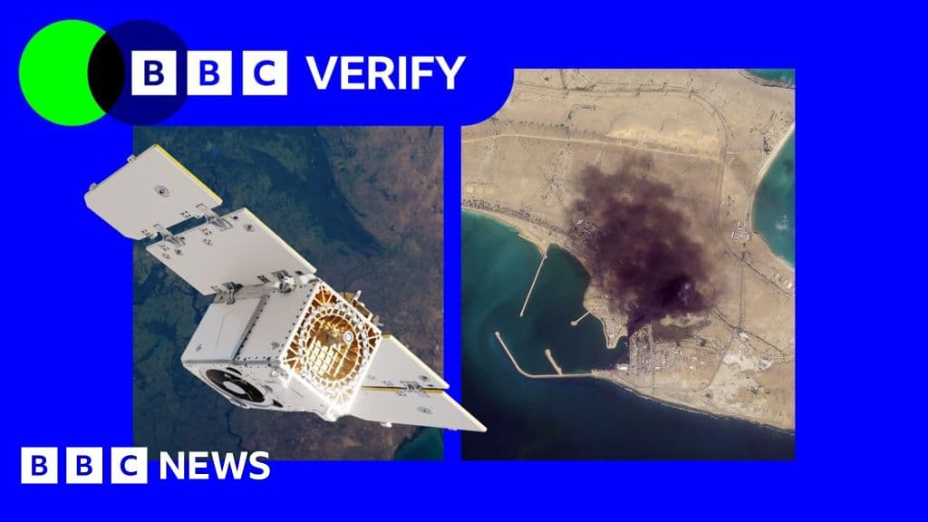
GlipzoA significant shift in satellite imagery access has surfaced as Planet Labs, a prominent satellite imaging company, announced it is limiting users' access to images of Iran and parts of the Middle East. This decision, made in response to requests from the US government, has raised red flags among humanitarian organizations and journalists alike. The restrictions began as a 14-day delay in March and have now escalated to an indefinite halt on providing new imagery from the region.
This change has profound implications for various stakeholders, including journalists, humanitarian groups, and military analysts. With the ongoing US-Israel conflict with Iran, the ability to visualize and assess damage to military installations and civilian infrastructure is crucial. However, the lack of current satellite imagery hampers these efforts. The specific reasons behind the US government's intervention remain unclear, as the Department of Defense has not commented on the matter.
Planet Labs initially justified its 14-day delay policy by stating it aimed to prevent adversarial forces from using its imagery to target allied personnel and civilians. In a recent statement to BBC Verify, the company indicated it would now implement a system of “managed distribution,” where selected images will be shared on a case-by-case basis as security risks evolve.
The breadth of these restrictions is troubling, as sources indicate they include a wide range of areas across the Middle East, notably Iraq, Lebanon, Israel, and Gaza. An expert in satellite imaging noted that companies holding military contracts might implement voluntary compliance to adhere to requests that reflect commercial incentives rather than legal obligations.
Satellite imagery has become an indispensable tool for reporters covering conflicts and crises. According to investigative journalist Benjamin Strick, these images are particularly vital in regions that are difficult or dangerous to access, allowing reporters to gather information where traditional reporting methods are blocked or restricted. For example, since late February, BBC Verify has utilized Planet's imagery to cover significant events, including a US strike on a school in Minab, Iran.
However, the new measures mean that images taken after March 9 are no longer available to clients, significantly impacting ongoing coverage of critical events in the region. With the potential for misinformation in conflict zones, access to accurate satellite data is paramount.
Planet Labs, similar to other satellite imaging companies, has increasingly partnered with the US defense sector. Its collaborations include contracts with the US National Geospatial Intelligence Agency and the US Navy, while also extending its services to the German and Swedish militaries. In contrast, Vantor, formerly known as Maxar, which has contracts with the US Army and US Space Force, stated it has not faced similar pressures from the Pentagon regarding restrictions on imagery over Iran.
Bill Greer, a geospatial analyst and co-founder of the non-profit organization Common Space, remarked on the delicate balance these companies must maintain. The intertwining of government relationships and commercial interests can create a scenario where compliance appears voluntary but is influenced by the need to retain significant clients like the government.
The implications of restricting satellite imagery extend beyond just journalistic reporting. Humanitarian organizations, which often rely on satellite data for planning and executing missions during crises, face significant challenges. Oxfam, for instance, has utilized satellite imagery to coordinate logistics and aid delivery in conflict zones. Magnus Corfixen, the charity's humanitarian lead, stated that in regions like Gaza, where Planet has also suspended coverage, satellite images play a crucial role in managing their water, sanitation, and hygiene (Wash) programs.
Corfixen highlighted the challenges posed by the inability to access critical water systems directly, emphasizing the importance of satellite services in maintaining essential services during emergencies. The restrictions not only hinder humanitarian efforts but can also lead to dire consequences for civilians in affected areas.
As the situation evolves, the ongoing restrictions on satellite imagery raise important questions about accountability, transparency, and the balance between national security and humanitarian needs. Observers will be keenly watching to see if these limitations remain in place and how they affect both reporting and humanitarian operations in the region.
The future of satellite imagery access will be pivotal in shaping how conflicts are reported and how aid organizations operate in areas facing humanitarian crises. Moving forward, it is crucial for stakeholders to advocate for unimpeded access to satellite imagery, ensuring that both humanitarian efforts and journalistic integrity are upheld during these challenging times. The intersection of technology, government policy, and humanitarian needs will continue to be a significant point of discussion.
In conclusion, the ramifications of the US government's pressure on Planet Labs highlight the delicate interplay between commercial interests and the ethical responsibilities of companies involved in the satellite imagery sector. As the world watches, the hope remains that transparency and access will prevail, allowing for informed reporting and effective humanitarian responses.

Survivors of the Laos cave rescue are aiding efforts to find the last two missing men trapped inside, sharing crucial insights for the search operation.
BBC World
A year after the tragic Air India crash, the Ali family reflects on grief, unanswered questions, and the enduring bonds of love in the face of loss.
BBC Business
A devastating explosion in Myanmar's Kaung Tat village has killed at least 55 people, raising serious safety concerns and questions about civilian protection in conflict zones.
BBC World